Climate change is fast creeping up where its effects are becoming more real, and less of a vague unfathomable concept. For the shipping industry, the drying up of the Mississippi River is a case in point. The serious drought in much of the United States over the past several months has impacted the Mississippi River, the second-longest river in North America after the Missouri River. It flows 2,350 miles from its source at Lake Itasca through the centre of the continental United States to the Gulf of Mexico. Some describe the Mississippi River as being the third-longest river system in the world. Known as a water super highway, it has been said that one-twelfth of the world's population eats something that emanates from the Mississippi River Basin and forty percent of global food supply starts at the Mississippi River Basin. Therefore it is a grave concern that water levels have fallen so low in some places, that they surpassed records set more than 30 years ago.
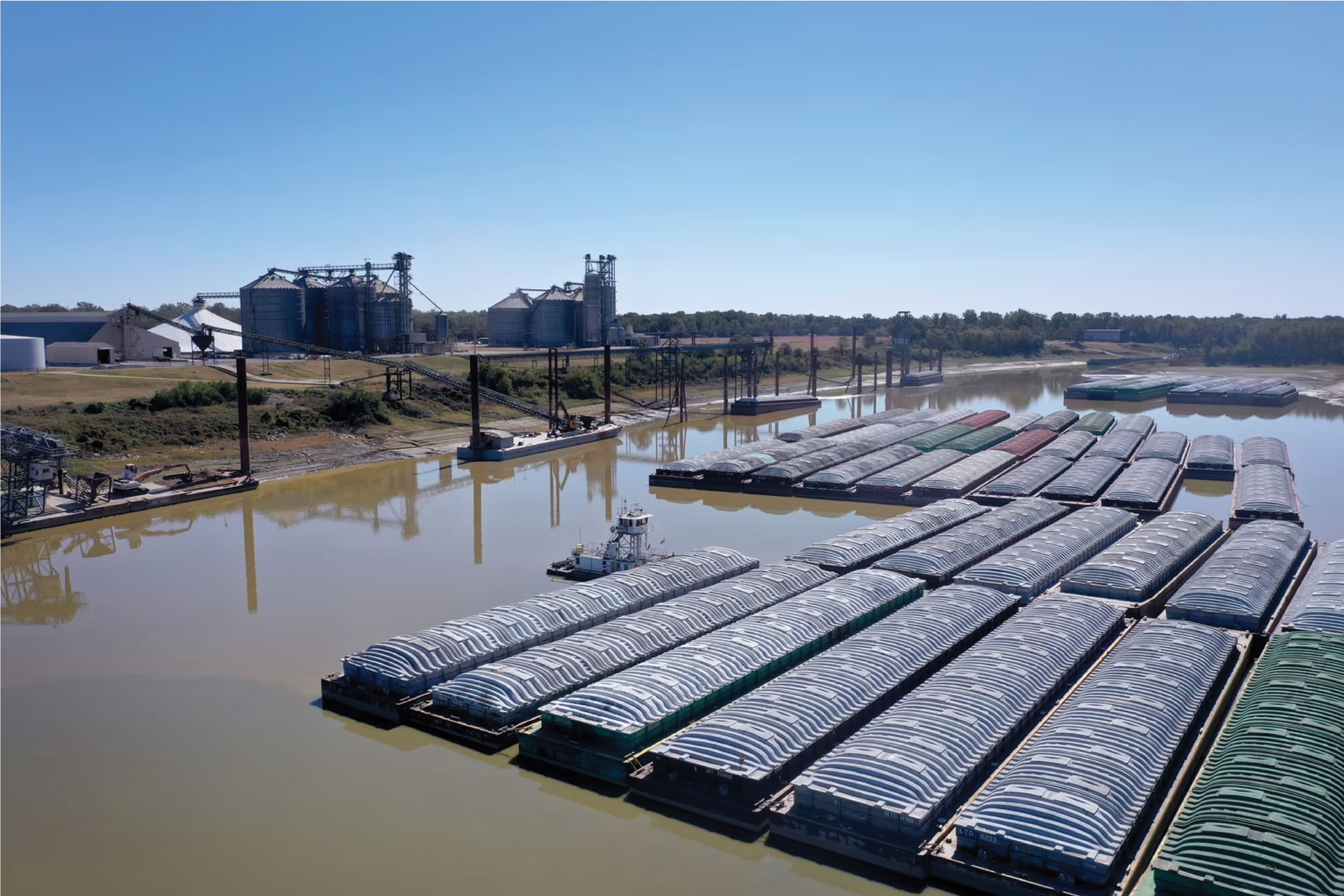
The Mississippi River is an important route for commerce. Thousands of barges haul essential commodities such as gas, coal, fertilizer and building materials along the 3,766-kilometer stretch of waterway. While barges are cheaper and more environmentally friendly to use than trucks or railways, the low water levels are making it difficult for boats to clear some parts of the river, and the U.S. Army Corps of Engineers is dredging to maintain a channel for the barges, which are moving very slowly along the Mississippi. Agricultural exports like corn, wheat and soybeans are being moved downriver for export, and that’s why these disruptions due to low water are so significant. With the war in Ukraine, global buyers are turning to the United States to purchase agricultural products, and European countries are purchasing coal for energy to fill the gap from Russia. More than a third of the rain in the United States ends up in the Mississippi River system. With little or no rainfall coming from the Midwest, the drought is causing problems along the river. Ships and barges are running aground, and navigation is slowed up and down the busy shipping corridor.
Similarly in China, parts of the Yangtze River, whose surrounding provinces produce 45 percent of the country’s economic output, were closed to ships because water levels were more than 50 percent below average. Meanwhile, two-thirds of Europe experienced drought conditions in 2022, as the continent saw its worst dry spell in at least 500 years. Last summer, the drying up of Europe’s waterways disrupted an US $ 80 Bn trade business, affecting oil refining, chemical production, power generation and corn farming.
The problem of rivers drying up is further compounded by ground water or wetlands becoming parched. Functioning as natural sponges, wetlands are supposed to be permanently saturated with water. Apart from providing water for drinking and irrigation it keeps water flowing into streams, rivers, lakes and reservoirs. During periods of low water levels in lakes and rivers, the slow discharge of groundwater to surface waters often helps maintain minimum water levels by releasing stored water directly into these systems.
At one time, there were extensive wetlands around New Orleans and other coastal communities that provided a natural resilience to storms. In total, about 50 miles (80 kilometres) of marshland once protected New Orleans from the Gulf, with trees and marsh grasses that blocked the winds and blunted storm surges. Today coastal Louisiana is losing 24 square miles of wetlands each year—roughly equivalent to a football field every 100 minutes. Since the 1930s, Louisiana has lost an area of coastal land equal to the size of the state of Delaware. If this rate of wetland loss is not slowed, by the year 2040 the coastal shoreline will advance inland as much as 33 miles (53 kilometres) in some areas.
Wetland loss occurs because of natural causes—subsidence and wave erosion; as well as human causes - construction of river levees, channels, canals, lands reclaimed for agricultural purposes or urban development. The natural balance of the wetlands in the Mississippi River Delta too have been disrupted. Prior to human development, natural wetland loss was replenished by Mississippi River sediments and nutrients creating new wetlands. Human activities have the unfortunate side effect of causing the Mississippi River sediments to go straight down the river's channel and into the Gulf of Mexico. Not only are wetlands being destroyed, but the natural cycle that rebuilds them is also being disrupted.
In the aftermath of Hurricane Katrina, one of the lessons learned is that a healthy system of wetlands between New Orleans and the Gulf almost certainly would have slowed down the storm and dampened the storm surge. Without natural storm buffers, breaches in levees such as those after Hurricane Katrina could become an even bigger threat. Wetlands serve as nature's first line of defence by absorbing much of the damage caused by hurricanes.
These incidents bring home the fact that this is not just a sign of the times to come but is the world’s collective reality. We cannot take for granted that rivers are perennial, and if we aren’t conscious, we may go too far down the path of self-destruction, to be able to press the rewind button and undo what is coming undone now.
Could some of the other well-known navigable waterways have the same fate?
Panama Canal -
Length 82 km: Width 150 m:
Depth: 12 m
In 1934 it was estimated that the maximum traffic of the canal would be around 80 Mn ton of shipping a year, but by 2015, canal traffic exceeded 340 Mn ton of shipping – over 4 times the original estimate. Today, nearly 15,000 ships pass through the Isthmus of Panama via the Canal annually.
Suez Canal -
Length 193 km: Width 205 m:
Depth: 20 m
The canal offers vessels a direct route between the North Atlantic and northern Indian oceans via the Mediterranean Sea and the Red Sea, avoiding the South Atlantic and southern Indian oceans. This reduces the distance from the Arabian Sea to London by approximately 8,900 kilometres (5,500 mi), or 10 days at 20 knots (37 km/h; 23 mph).
Kiel Canal -
Length 98 km: Width 100 m:
Depth: 11 m
The Kiel Canal is the world's most frequented artificial waterway with an annual average of 32,000 ships (90 daily), transporting approximately 100 Mn ton of goods.
Houston Ship Channel -
Length 80 km: Width 160 m:
Depth: 11 m
The 52-mile Houston Ship Channel is one of America’s most important waterways, serving to connect the nation’s largest petrochemical
complex with global markets. It accounts for over 16 percent of the total GDP for the state of Texas.